Do you know how the smart tracker locates your pets? why do the signals weaken in some areas? Why doesn’t work indoors? The modern powerful pet solution—— the smart tracker uses an amazing array of positioning systems to track and protect your pets. From space-based satellites to your home’s WiFi, these smart devices work like guardian angels, keeping watch over our pets day and night. Let’s explore how these different tracking methods work indoors and outdoors to bring your pets home safely.
5 Major Positioning Methods
First of all, we will introduce 5 major positioning methods of the smart tracker.
1. Satellite Global Positioning Method
Here, we will introduce 5 positioning ways that depend on the satellite.
GPS (Global Positioning System)
GPS(America) sends signals from 31 satellites orbiting at 20,200 kilometers above Earth. Each satellite broadcasts a unique radio signal containing its location and timing data. When your GPS receiver catches signals from at least four satellites, it calculates your position through trilateration. This process measures the distance between you and each satellite based on how long the signals take to reach your device.
Civilian GPS offers 5-10 meter accuracy for navigation, human and pet tracking, and more. It powers everything from car navigation to pet trackers, smartphone apps, and emergency services. The system works in any weather, anywhere on Earth, though signals can weaken indoors or in dense urban areas.
GLONASS (Global Navigation Satellite System)
GLONASS(Russia) operates 24 satellites in three orbital planes, each satellite circling Earth every 11 hours 15 minutes. The system uses FDMA (Frequency Division Multiple Access) technology, meaning each satellite transmits at its own frequency. This design helps reduce signal interference and mix-ups, so as to improve locating accuracy in challenging environments.
The Russian system excels in northern latitudes where GPS sometimes struggles, providing reliable positioning even in extreme northern conditions. It delivers accuracy similar to GPS and often works alongside it on modern devices.
Galileo
Galileo(EU) stands out with its modern satellite design and advanced signal structure. Its 30 satellites broadcast on multiple frequencies, enabling correction of signal delays in Earth’s atmosphere. This technology helps Galileo achieve impressive accuracy – down to 1 meter for users. This high precision helps pinpoint your pet in complex urban environments. Galileo’s strong signals penetrate better through city obstacles. When your dog sneaks between buildings or under structures, Galileo helps keep tabs on their location.
BeiDou
BeiDou(China) uses 35 satellites in different orbital paths to provide global coverage. The system combines satellites in high Earth orbit, geostationary orbit, and inclined geosynchronous orbit. This unique arrangement ensures excellent coverage over Asia while maintaining global service. BeiDou offers a standard positioning accuracy of 10 meters globally and 5 meters in the Asia-Pacific region.
Beyond positioning, BeiDou provides a distinct two-way communication feature. Users can send short messages through the system, even in areas without cellular coverage. This capability makes BeiDou valuable for emergency communications and remote area operations. If you lost your pet in a remote area, BeiDou-equipped trackers can still alert you about their location. This dual positioning and messaging capability adds an extra safety layer.
QZSS (Quasi-Zenith Satellite System)
QZSS(Japan) complements GPS with four satellites following unique figure-8-shaped paths over East Asia and Oceania. These orbits keep satellites high in the sky over Japan, solving the urban canyon problem where tall buildings block traditional satellite signals. The system sends correction data to GPS receivers, dramatically improving positioning accuracy.
While not a fully global system, QZSS significantly enhances navigation accuracy in its coverage area. It’s particularly valuable in Japan’s dense urban environments and supports applications requiring high precision.
2. LBS positioning method
LBS (Location-Based Services) positioning uses cellular networks to find locations. It works by measuring signals between your device and nearby cell towers. Cell towers create a network of coverage areas across cities and towns. Each tower has a known location and specific signal strength. Your device connects to multiple towers at once.
The system needs less power than GPS. Coverage extends anywhere with cell service. However, accuracy varies from 50 to 1000 meters, depending on tower density. Cities offer better accuracy than rural areas due to more towers. Pet trackers use LBS as a reliable backup to GPS. When your pet goes indoors or under cover, LBS keeps tracking. The system tells you which cell towers detect your pet’s tracker. This creates a general area where your pet might be. While not as precise as GPS, it helps narrow down the search area.
3. WiFi positioning method
WiFi positioning finds locations using nearby WiFi networks. By the signals from routers, the system calculates your pets’ position. Regarding the WiFi routers as indoor landmarks, they help navigate through buildings and cities. The system matches WiFi signals against a database of known router locations. Strong signals mean you’re close to a router. Weak signals indicate greater distance. Accuracy typically ranges from 15 to 50 meters indoors.
Pet trackers scan nearby WiFi networks as your pet moves around. The WiFi positioning can also used in the geofence that allows owners to set a safe zone within the range of WIFI signals that the tracker connects with. It works great and precisely for indoor protection.
4. Bluetooth Positioning Method
Bluetooth positioning uses short-range radio signals to find objects or pets. It measures the strength of signals between devices to calculate distance. Modern Bluetooth technology works best within 30-100 meters. Walls and furniture can block signals. The system uses very little power, making it ideal for small trackers. Best of all, it gives precise locations indoors where GPS fails.
Your pet’s tracker sends out regular Bluetooth signals and your phone measures these signals’ strength. The distance between your pets and your phone affects the signal strength. The system gets more accurate as you move closer to your pet. Moreover, the tracker with Bluetooth positioning is capable of creating a virtual fence around your home. Your phone alerts you if your pet leaves this area. Inside the house, Bluetooth guides you right to your pet.
5. AGPS((Assisted GPS) Positioning
AGPS combines traditional GPS with cellular network assistance. It speeds up location finding by using cell towers to get rough positions first. You can think of it as GPS with a head start. Instead of searching blindly for satellites, AGPS knows where to look. This makes position fixing much faster than standard GPS.
The pet smart tracker gets satellite data through cellular networks first. This data tells where satellites should be in the sky, helping the tracker connect to actual GPS satellites more quickly. The AGPS works well outdoors and helps the tracker find pets, especially in new areas
The combination of various positioning methods
No single positioning method works perfectly in all situations. That’s why modern pet trackers combine multiple methods, ensuring you can find your pet anywhere, anytime.
Outdoor Tracking Solutions
GPS and other several satellite positioning ways lead the way outdoors. It offers accurate positions in open areas. Though the GPS supported by the satellite covers the whole earth, its signals can weaken or disappear in some places, especially those remote areas.
When GPS signals weaken, AGPS and LBS(if the tracker is equipped with them) step in. AGPS speeds up satellite connections through cellular networks as AGPS already knows where these satellites are. It tells your smart pet tracker exactly where to look for GPS satellites. Meanwhile, LBS uses nearby cell towers to maintain rough positioning. If your pet wanders into areas with weak GPS signals, these systems take over smoothly. AGPS helps reconnect to satellites quickly, while LBS provides continuous backup tracking. Moreover, this teamwork uses less battery power than GPS alone.
This combo provides quick, reliable outdoor tracking. Even when your pet runs into new neighborhoods, these systems work together to maintain location updates.
Indoor Tracking Solutions
GPS is also useful for indoor locating, but it may be unreliable. Dense building materials like concrete and metal severely block or weaken these already faint signals. Additionally, when GPS signals hit buildings, they often bounce off surfaces, creating multiple reflected signals that confuse GPS receivers. Moreover, each floor above adds another layer of interference, and the deeper you go into a building, the worse it gets.
In such a situation, the Wifi and Bluetooth positioning exert influence for their short-distance positioning. WiFi positioning uses nearby routers to locate your pet within a 15-50 meter range. This works perfectly for identifying which room or floor your pet is on. Meanwhile, Bluetooth takes over for close-range detection, working effectively within 30-100 meters. The Bluetooth signals get stronger as you move closer to your pet, guiding you right to their hiding spot. Most importantly, your pet tracker switches between these methods automatically.
This smart integration makes modern pet trackers more reliable than ever. You get the best of each technology without dealing with individual limitations.
Choose the perfect smart tracker for your pets
After understanding these positioning methods, one thing becomes clear: the best pet trackers combine multiple technologies. Each method has its strengths, and together they create a safety net for your pet.
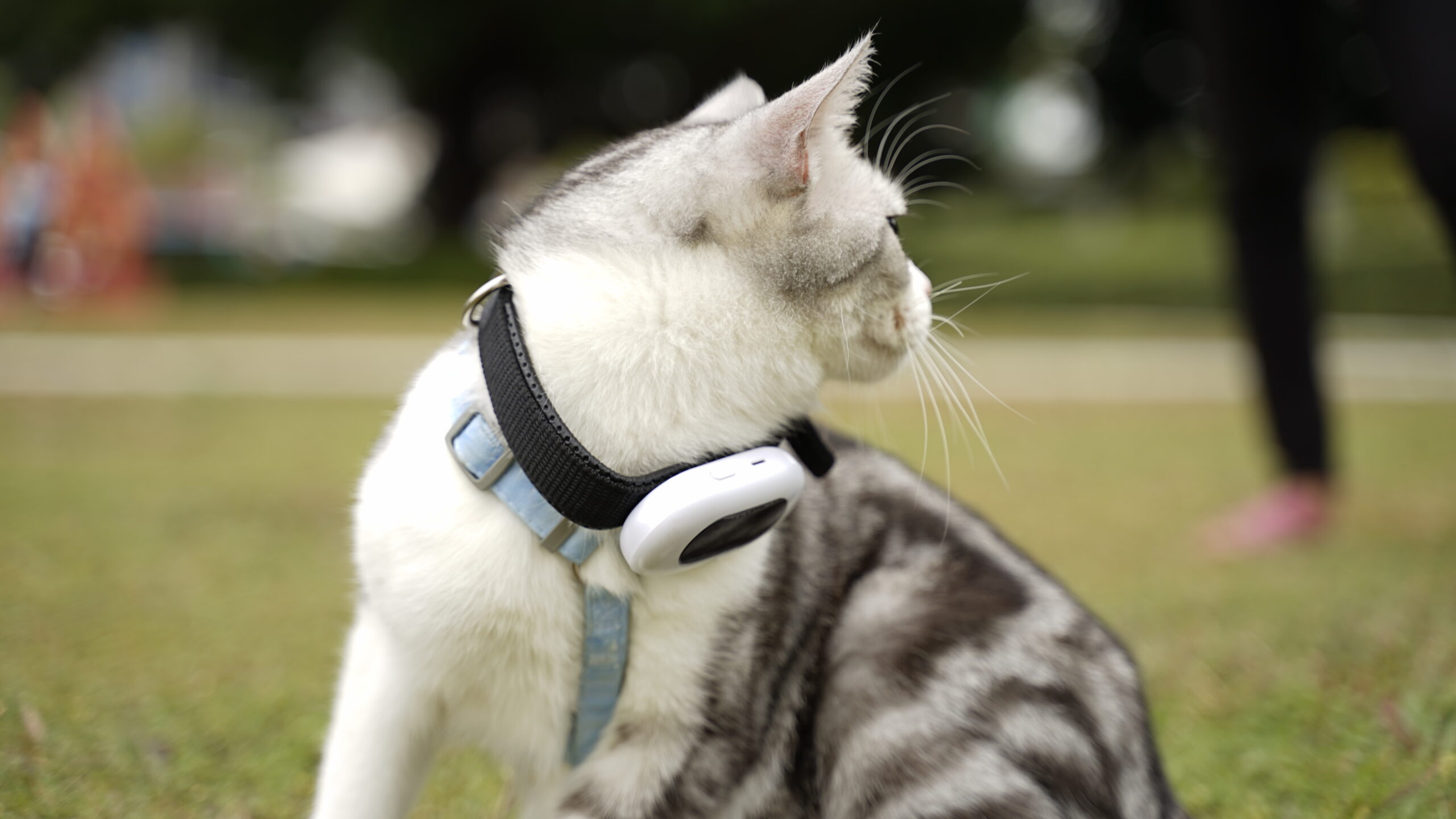
Take the Beardpet Dog Tracking Collar V43, for example. This advanced tracker brings together five powerful tracking methods: GPS, LBS, WiFi, BeiDou, and AGPS. This combination ensures your pet stays visible everywhere. Moreover, its three mapping options – Google, Baidu, and Satellite View – let you spot your pet from every angle. Think of it as having three different pairs of eyes watching your pet at once.
Invest in a reliable tracker today. After all, our pets are family – and family deserves the best protection we can give them. Contact us to learn more about our V43 smart tracker to give your family great welfare.